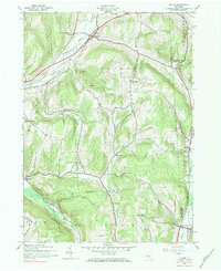
1943 Map of Cuyler
USGS Topo · Published 1984About this map
The Lehigh Valley railroad line cuts through the northern reaches of this rural landscape, following the valley of the East Branch Tioughnioga River toward the settlement of Cuyler. This mid-century survey reveals a highly distributed rural society defined by numbered and named school districts, such as School No 14 and the evocatively named Black Warrior Sch. The topography is dominated by a series of prominent rises including Richmond Hill and Pease Hill, which channeled development into narrow corridors along waterways like Cheningo Creek and Mason Creek. Evidence of early community centers remains at Union Valley and Potter Hill, where the Potter Hill Cem and School No 1 served the surrounding farming families. This map preserves the transition from traditional upland agriculture to the modern rural layout seen in the latter half of the twentieth century.
Find a feature on this map
39 named features on this map. Tap any name to fly to it.
Don’t see what you’re looking for? This feature index may not catch every label — zoom into the map to look around manually.
Map Details
Editions of this 1943 Cuyler Map
4 editions found


Other maps of this area

1897 · Cazenovia
USGS Topo · 1:62,500

1899 · Cazenovia
USGS Topo · 1:62,500

1900 · Tully
USGS Topo · 1:62,500

1903 · Cortland
USGS Topo · 1:62,500

1904 · Pitcher
USGS Topo · 1:62,500
1943 · Tully
USGS Topo · 1:24,000

1943 · De Ruyter
USGS Topo · 1:24,000

1943 · South Ostelic
USGS Topo · 1:24,000

1943 · Cincinnatus
USGS Topo · 1:24,000
1943 · Erieville
USGS Topo · 1:24,000