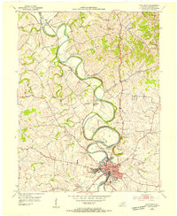
1953 Map of Cynthiana
USGS Topo · Published 1955About this map
The South Fork Licking River carves a dramatic, winding path through Harrison County, serving as the central topographical spine for this mid-century survey. Along its banks, the city of Cynthiana stands as a significant hub, anchored by civic and educational institutions like the Banneker Sch and the County High Sch. The town's layout reflects its role as a regional center, with the Memorial Hospital and several large cemeteries, including Battle Grove Cem and Cherry Grove Cem, clustered near the river’s bend.
Find a feature on this map
32 named features on this map. Tap any name to fly to it.
Don’t see what you’re looking for? This feature index may not catch every label — zoom into the map to look around manually.
Map Details
Editions of this 1953 Cynthiana Map
This is the sole edition of this map. No revisions or reprints were ever made.
Other maps of this area

1929 · Cynthiana
USGS Topo · 1:48,000

1930 · Falmouth
USGS Topo · 1:48,000

1934 · Cynthiana
USGS Topo · 1:62,500

1936 · Falmouth
USGS Topo · 1:62,500

1952 · Shady Nook
USGS Topo · 1:24,000

1952 · Claysville
USGS Topo · 1:24,000

1953 · Millersburg
USGS Topo · 1:24,000

1953 · Berry
USGS Topo · 1:24,000

1953 · Breckinridge
USGS Topo · 1:24,000

1953 · Kelat
USGS Topo · 1:24,000