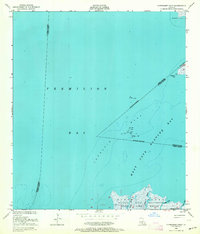
1948 Map of Cypremort Point
USGS Topo · Published 1964About this map
Marsh Island anchors the southern reaches of this mid-century survey, a landscape defined by the expansive waters where Vermilion Bay meets West Cote Blanche Bay. This coastal environment is documented during a period of transition, showing the early infrastructure of the petroleum industry alongside protected conservation lands. Significant offshore features like Terrapin Reef are meticulously marked with markers for piles and oil platforms, reflecting the maritime and industrial activity common to the Louisiana gulf.
Find a feature on this map
24 named features on this map. Tap any name to fly to it.
Don’t see what you’re looking for? This feature index may not catch every label — zoom into the map to look around manually.
Map Details
Editions of this 1948 Cypremort Point Map
2 editions found
Other maps of this area

1932 · Bayou Blanc
USGS Topo · 1:31,680

1932 · Abbeville SE
USGS Topo · 1:31,680

1937 · Derouen
USGS Topo · 1:62,500

1945 · New Orleans
USGS Topo · 1:250,000

1946 · Redfish Point NE
USGS Topo · 1:31,680

1946 · Redfish Point SE
USGS Topo · 1:31,680
1948 · Bayou Blanc
USGS Topo · 1:24,000

1948 · Cypremort Point
USGS Topo · 1:24,000

1949 · Cypremort Pt
USGS Topo · 1:31,680

1949 · Bayou Lucien
USGS Topo · 1:31,680