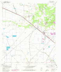
1970 Map of Cypress
USGS Topo · Published 1980About this map
The Southern Pacific railroad cuts a diagonal line across this Harris County landscape, anchoring the settlement of Cypress and the nearby Hot Wells area. The 1970 field check, updated in 1980, reveals a community transitioning from rural prairie to early suburban expansion, evidenced by the purple-tinted urban revisions around Cy-Fair High Sch and Arnold Jr High Sch. This era captures the intricate network of family heritage preserved in local burial grounds such as Graves Cem, Roeder Cem, Muller Cem, and Knigge Cem, scattered among the drainages of Cypress Creek and Little Cypress Creek. The southern edge is defined by the upper reaches of the Addicks Reservoir floodpool, where Langham Creek and Horsepen Creek converge. Landmarks like the Rodeo Ground and Weiser Airport illustrate the local character of the period before the heavy residential development of the late 20th century.
Find a feature on this map
38 named features on this map. Tap any name to fly to it.
Don’t see what you’re looking for? This feature index may not catch every label — zoom into the map to look around manually.
Map Details
Editions of this 1970 Cypress Map
3 editions found
Other maps of this area

1915 · Cypress
USGS Topo · 1:24,000

1915 · Katy
USGS Topo · 1:24,000

1915 · Addicks
USGS Topo · 1:24,000

1915 · Hillendahl
USGS Topo · 1:24,000

1916 · Rose Hill
USGS Topo · 1:24,000

1916 · Louetta
USGS Topo · 1:24,000

1916 · Hockley
USGS Topo · 1:24,000

1916 · Satsuma
USGS Topo · 1:24,000

1916 · Swanson
USGS Topo · 1:24,000

1918 · Cypress
USGS Topo · 1:31,680