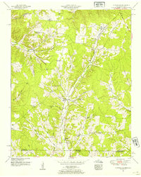
1951 Map of Cypress Inn
USGS Topo · Published 1954About this map
The Tennessee-Alabama border country in the early 1950s is defined by the winding course of Cypress Creek and its many tributaries, such as Weatherford Creek and Holt Branch. Small farming communities and rural hubs like Cypress Inn anchor the landscape, which is traversed by the historic Natchez Trace Parkway and Chisholm Road. The map reveals a dense network of local social centers, featuring numerous rural schools including Cheatham School, Rose Sch, and Barnett Sch, alongside congregational landmarks like Piney Grove Ch and Mt Pleasant Church. Genealogists will find significant detail in the family-named cemeteries scattered across the terrain, from Balentine Cem to Powell Cem, providing a clear view of the settlement patterns and local lineages in this borderland between Wayne County and Lauderdale County before modern consolidation.
Find a feature on this map
45 named features on this map. Tap any name to fly to it.
Don’t see what you’re looking for? This feature index may not catch every label — zoom into the map to look around manually.
Map Details
Editions of this 1951 Cypress Inn Map
3 editions found
Other maps of this area

1905 · Waynesboro
USGS Topo · 1:125,000

1914 · Muscle Shoals
USGS Topo · 1:48,000

1916 · Muscle Shoals
USGS Topo · 1:62,500

1924 · Gravelly Springs
USGS Topo · 1:48,000

1926 · Gravelly Springs
USGS Topo · 1:62,500

1935 · Wright
USGS Topo · 1:24,000

1936 · Collinwood
USGS Topo · 1:24,000

1936 · Light
USGS Topo · 1:24,000

1936 · Threet
USGS Topo · 1:24,000

1936 · Cypress Inn
USGS Topo · 1:24,000