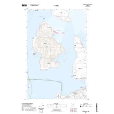
2020 Map of Cypress Island
USGS Topo · Published 2020About this map
Cypress Island and the surrounding San Juan archipelago characterize this maritime study, where the peaks of Eagle Cliff and Olivine Hill rise above the cold waters of Rosario Strait. The rugged coastline is marked by deep inlets like Strawberry Bay and Secret Harbor, while the interior remains sparsely developed, punctuated by Duck Lake and Cypress Lake. To the east, Guemes Island shows a more residential pattern with Indian Village and the settlement of Guemes, including the Eden Cem. The southern edge captures the industrial and transit hub of Anacortes, featuring the Anacortes Airport and the complex ferry routes of the Guemes Channel, such as the Anacortes - Friday Harbor Ferry. The map records a landscape where maritime transport and topographic elevation dictate the layout of small settlements like Urban on Sinclair Island.
Find a feature on this map
72 named features on this map. Tap any name to fly to it.
Don’t see what you’re looking for? This feature index may not catch every label — zoom into the map to look around manually.
Map Details
Editions of this 2020 Cypress Island Map
This is the sole edition of this map. No revisions or reprints were ever made.
Other maps of this area

1943 · Richardson
USGS Topo · 1:62,500

1943 · Orcas Island
USGS Topo · 1:62,500

1943 · Deception Pass
USGS Topo · 1:62,500

1943 · Anacortes
USGS Topo · 1:62,500

1951 · Deception Pass
USGS Topo · 1:62,500

1951 · Anacortes
USGS Topo · 1:62,500

1957 · Richardson
USGS Topo · 1:62,500

1957 · Orcas Island
USGS Topo · 1:62,500

1957 · Victoria
USGS Topo · 1:250,000

1973 · Cypress Island
USGS Topo · 1:24,000