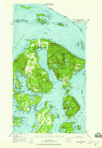
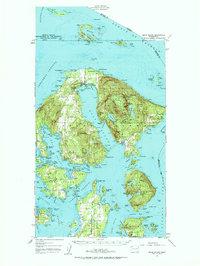
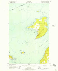
1957 Map of Orcas Island
USGS Topo · Published 1959About this map
Moran State Park dominates the eastern heights of Orcas Island, anchored by the massive bulk of Mount Constitution and the surrounding high-elevation waters of Mountain Lake and Twin Lakes. This 1957 revision of the earlier 1941 topography illustrates the complex archipelago of the San Juan Islands, where the landscape is defined by deep inlets like East Sound and West Sound. The map documents a mix of recreational and residential growth, featuring established retreats such as Buckhorn Lodge and Camp Orkila alongside older maritime settlements like Deer Harbor and Doe Bay. Beyond the main island, the map tracks smaller outposts and navigational landmarks including Patos Island with its light station at Alden Pt, the rocky shores of Sucia Island, and the agricultural patterns around Lopez and Port Stanley.
Find a feature on this map
142 named features on this map. Tap any name to fly to it.
Don’t see what you’re looking for? This feature index may not catch every label — zoom into the map to look around manually.
Map Details
Editions of this 1957 Orcas Island Map
2 editions found
Other maps of this area
1907 · Blaine
USGS Topo · 1:62,500

1943 · Richardson
USGS Topo · 1:62,500

1943 · Orcas Island
USGS Topo · 1:62,500

1943 · Deception Pass
USGS Topo · 1:62,500

1943 · Anacortes
USGS Topo · 1:62,500

1951 · Deception Pass
USGS Topo · 1:62,500

1951 · Anacortes
USGS Topo · 1:62,500
1952 · Lummi Bay
USGS Topo · 1:24,000
1952 · Blaine
USGS Topo · 1:62,500
1954 · Waldron Island
USGS Topo · 1:24,000