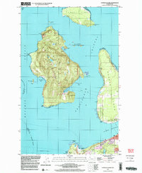
1997 Map of Cypress Island
USGS Topo · Published 2003About this map
Cypress Island and Sinclair Island anchor this coastal survey, which reveals the maritime infrastructure of the northern Puget Sound at the end of the 20th century. The intricate shoreline is marked by essential navigation aids like Sinclair Island Light and Cypress Island Light, while the inland terrain of Cypress Island remains largely undeveloped, featuring Cypress Lake and Duck Lake amidst several named springs. On the northern shore of Sinclair, the small settlement of Urban is visible, reflecting the isolated island life of the era.
Find a feature on this map
50 named features on this map. Tap any name to fly to it.
Don’t see what you’re looking for? This feature index may not catch every label — zoom into the map to look around manually.
Map Details
Editions of this 1997 Cypress Island Map
This is the sole edition of this map. No revisions or reprints were ever made.
Other maps of this area

1943 · Richardson
USGS Topo · 1:62,500

1943 · Orcas Island
USGS Topo · 1:62,500

1943 · Deception Pass
USGS Topo · 1:62,500

1943 · Anacortes
USGS Topo · 1:62,500

1951 · Deception Pass
USGS Topo · 1:62,500

1951 · Anacortes
USGS Topo · 1:62,500

1957 · Richardson
USGS Topo · 1:62,500

1957 · Orcas Island
USGS Topo · 1:62,500

1957 · Victoria
USGS Topo · 1:250,000

1973 · Cypress Island
USGS Topo · 1:24,000