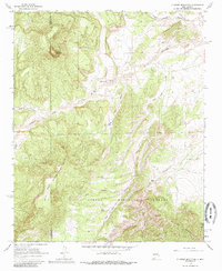
1964 Map of D Cross Mountain
USGS Topo · Published 1985About this map
D Cross Mountain stands as a prominent landmark in this mid-1960s survey of the high desert terrain where the Datil Mountains and Gallinas Mountains meet. The landscape is defined by a complex network of drainage systems, including Alamocita Creek and Miguel Chavez Canyon, which flow through the protected lands of the Cibola National Forest. Human presence in this arid environment is marked by essential water management features such as Rock Tank and Blue Mesa Tank, along with several Prospects that hint at localized mineral exploration. The presence of the Martin Ranch and isolated water sources like INM Springs reflects the ranching heritage of the Catron and Socorro county border region. This map effectively illustrates the precarious balance of water and resource extraction in a high-elevation Southwestern wilderness before the era of modern development.
Find a feature on this map
20 named features on this map. Tap any name to fly to it.
Don’t see what you’re looking for? This feature index may not catch every label — zoom into the map to look around manually.
Map Details
Editions of this 1964 D Cross Mountain Map
2 editions found
Other maps of this area

1917 · Broom Mountain
USGS Topo · 1:125,000

1954 · Socorro
USGS Topo · 1:250,000

1958 · Socorro
USGS Topo · 1:250,000

1962 · Socorro
USGS Topo · 1:250,000

1963 · Cal Ship Mesa
USGS Topo · 1:24,000

1964 · Indian Mesa
USGS Topo · 1:24,000

1964 · Table Mountain
USGS Topo · 1:24,000

1964 · Wiley Mesa
USGS Topo · 1:24,000

1964 · Dog Springs
USGS Topo · 1:24,000

1964 · Pasture Canyon
USGS Topo · 1:24,000