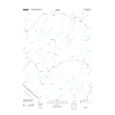
2013 Map of Dabneys
USGS Topo · Published 2013About this map
The South Anna River and Newfound River carve through this rural Virginia landscape, defining a network of family-held lands and historic crossroads. Small settlements such as Holly Grove and Locust Creek serve as anchors for a region where the names of long-standing farms and local commerce, such as Johnsons Mill Farm and Duggins Store, are still recorded on the land. The presence of Sheltons Millpond and several creek systems like Owens Creek and Leatherwood Cr highlights the water-driven development patterns typical of central Virginia’s Piedmont region.
Find a feature on this map
84 named features on this map. Tap any name to fly to it.
Don’t see what you’re looking for? This feature index may not catch every label — zoom into the map to look around manually.
Map Details
Editions of this 2013 Dabneys Map
This is the sole edition of this map. No revisions or reprints were ever made.
Other maps of this area

1890 · Goochland
USGS Topo · 1:125,000

1892 · Goochland
USGS Topo · 1:125,000

1942 · Pendleton
USGS Topo · 1:24,000

1942 · Buckner
USGS Topo · 1:24,000

1942 · Beaverdam
USGS Topo · 1:24,000

1943 · Goochland
USGS Topo · 1:31,680

1943 · Mabelton
USGS Topo · 1:31,680

1943 · Perkinsville
USGS Topo · 1:31,680

1943 · Pendleton
USGS Topo · 1:31,680
1943 · Buckner
USGS Topo · 1:31,680