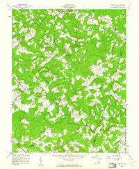
1943 Map of Dabneys
USGS Topo · Published 1961About this map
The South Anna River snakes through this rural landscape of central Virginia, defining the borders of Louisa, Hanover, and Goochland counties during the early 1940s. Small community hubs like Dabneys and Shelfar anchor a network of dirt and light-duty roads, while the area is notably dense with country churches such as Salem Ch and Mt Hope Ch. These landmarks, along with institutions like the Mt Zion Sch, indicate a well-established but decentralized agrarian society where social life revolved around local congregations and crossroads. Local geography is shaped by numerous tributaries including Taylor Creek and Locust Creek, which feed into the primary river valley. The presence of smaller settlements like Inez, Dongola, and Vontay provides a detailed view of family-named locales that were vital to the county's identity before the expansion of modern highways.
Find a feature on this map
31 named features on this map. Tap any name to fly to it.
Don’t see what you’re looking for? This feature index may not catch every label — zoom into the map to look around manually.
Map Details
Editions of this 1943 Dabneys Map
This is the sole edition of this map. No revisions or reprints were ever made.
Other maps of this area

1890 · Goochland
USGS Topo · 1:125,000

1892 · Goochland
USGS Topo · 1:125,000

1942 · Pendleton
USGS Topo · 1:24,000

1942 · Buckner
USGS Topo · 1:24,000

1942 · Beaverdam
USGS Topo · 1:24,000

1943 · Goochland
USGS Topo · 1:31,680

1943 · Mabelton
USGS Topo · 1:31,680

1943 · Perkinsville
USGS Topo · 1:31,680

1943 · Pendleton
USGS Topo · 1:31,680
1943 · Buckner
USGS Topo · 1:31,680