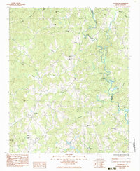
1983 Map of Dacusville
USGS Topo · Published 1983About this map
Dacusville serves as the central hub of this Pickens County landscape in the early 1980s, where the geography is defined by a dense network of rural congregations and family landmarks. The settlement pattern shows communities clustered around historic sites like Nine Forks Ch and Cross Roads Ch, reflecting a deep-rooted social fabric common to the South Carolina Piedmont. To the east, the North Saluda River and South Saluda River converge, forming the boundary between Pickens and Greenville counties.
Find a feature on this map
34 named features on this map. Tap any name to fly to it.
Don’t see what you’re looking for? This feature index may not catch every label — zoom into the map to look around manually.
Map Details
Editions of this 1983 Dacusville Map
This is the sole edition of this map. No revisions or reprints were ever made.
Other maps of this area

1888 · Pickens
USGS Topo · 1:125,000

1894 · Pickens
USGS Topo · 1:125,000

1905 · Pisgah
USGS Topo · 1:125,000

1906 · Pisgah
USGS Topo · 1:125,000

1907 · Saluda
USGS Topo · 1:125,000

1935 · Greenville
USGS Topo · 1:48,000

1935 · Table Rock
USGS Topo · 1:24,000

1938 · Greenville
USGS Topo · 1:62,500

1946 · Table Rock
USGS Topo · 1:24,000
1947 · Table Rock
USGS Topo · 1:24,000