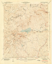
1947 Map of Table Rock
USGS Topo · Published 1947About this map
Table Rock State Park and the adjacent Table Rock Reservoir dominate this 1946 field-examined landscape along the North Carolina and South Carolina border. The terrain is defined by the Blue Ridge Divide and prominent peaks like Pinnacle Mtn, Table Rock, and The Stool. Outside the park boundaries, a rural network of small communities and schools reflects the mid-century agricultural character of Pickens and Greenville counties. Local life centers around places like Pumpkintown, while small educational and religious landmarks such as Rock School, Saluda Hill Church, and Soapstone Church are scattered through the valleys. The map also documents significant hydrological features, including the South Saluda River and the dramatic Raven Cliff Falls, as well as the family-named Cassell Cemeteries located near the headwaters of the East Fork French Broad River.
Find a feature on this map
65 named features on this map. Tap any name to fly to it.
Don’t see what you’re looking for? This feature index may not catch every label — zoom into the map to look around manually.
Map Details
Editions of this 1947 Table Rock Map
2 editions found
Other maps of this area

1888 · Pickens
USGS Topo · 1:125,000

1894 · Pickens
USGS Topo · 1:125,000

1905 · Pisgah
USGS Topo · 1:125,000

1906 · Pisgah
USGS Topo · 1:125,000

1935 · Brevard
USGS Topo · 1:24,000

1935 · Eastatoe Gap
USGS Topo · 1:24,000

1935 · Standingstone Mtn.
USGS Topo · 1:24,000

1935 · Rosman
USGS Topo · 1:24,000

1935 · Table Rock
USGS Topo · 1:24,000
1945 · Brevard
USGS Topo · 1:24,000