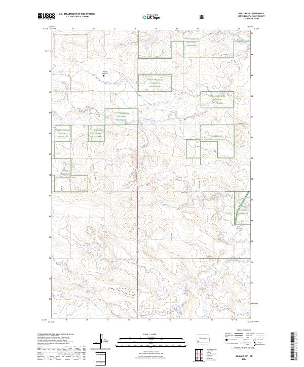
2024 Map of Daglum SW
USGS Topo · Published 2024About this map
The Little Missouri National Grassland dominates the landscape of this Slope County corner, where the High Plains topography is carved by a network of drainage systems. The Cannonball River flows across the southern portion of the sheet, while Philbrick Creek and Adobe Wall Creek define the northern drainages. These watercourses cut through the undulating terrain, creating the distinct relief patterns characteristic of the western North Dakota badlands. Cultural landmarks are sparse in this open country, making the Peaceful Valley Cem north of 56th St SW a significant point for genealogists and local historians. The section-line road network, including routes like 134th Ave SW, reveals the enduring grid of the Public Land Survey System that persists even within these protected grasslands.
Find a feature on this map
15 named features on this map. Tap any name to fly to it.
Don’t see what you’re looking for? This feature index may not catch every label — zoom into the map to look around manually.
Map Details
Editions of this 2024 Daglum SW Map
This is the sole edition of this map. No revisions or reprints were ever made.
Other maps of this area

1953 · Dickinson
USGS Topo · 1:250,000

1957 · Dickinson
USGS Topo · 1:250,000

1961 · Daglum
USGS Topo · 1:62,500

1961 · Rocky Ridge
USGS Topo · 1:62,500

1973 · White Lake
USGS Topo · 1:24,000

1973 · Amidon
USGS Topo · 1:24,000

1973 · West Rainy Butte
USGS Topo · 1:24,000

1980 · Belfield
USGS Topo · 1:100,000

1981 · Bowman
USGS Topo · 1:100,000
1982 · Daglum NW
USGS Topo · 1:24,000