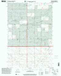
1997 Map of Daglum SW
USGS Topo · Published 2001About this map
Little Missouri River Valley terrain dominates this North Dakota landscape, where ranching and resource extraction define the local economy. The map illustrates a high-plains environment characterized by extensive grazing lands within the Little Missouri National Grassland. Cultural history is anchored by family-named holdings such as the H Hewson Ranch, H Howie Ranch, and Miller Ranch, reflecting the area's deep cattle-ranching roots. Industry is represented by the Rocky Ridge Oil Field and scattered infrastructure like an Oil Well. Hydrological features include the Cannonball River and Adobe Wall Creek, while the Peaceful Valley Cem serves as a quiet record of early settlement families. The land use pattern shown here reveals a balance between federal grassland preservation and active agricultural and energy production.
Find a feature on this map
18 named features on this map. Tap any name to fly to it.
Don’t see what you’re looking for? This feature index may not catch every label — zoom into the map to look around manually.
Map Details
Editions of this 1997 Daglum SW Map
This is the sole edition of this map. No revisions or reprints were ever made.
Other maps of this area

1953 · Dickinson
USGS Topo · 1:250,000

1957 · Dickinson
USGS Topo · 1:250,000

1961 · Daglum
USGS Topo · 1:62,500

1961 · Rocky Ridge
USGS Topo · 1:62,500

1973 · White Lake
USGS Topo · 1:24,000

1973 · Amidon
USGS Topo · 1:24,000

1973 · West Rainy Butte
USGS Topo · 1:24,000

1980 · Belfield
USGS Topo · 1:100,000

1981 · Bowman
USGS Topo · 1:100,000
1982 · Daglum NW
USGS Topo · 1:24,000