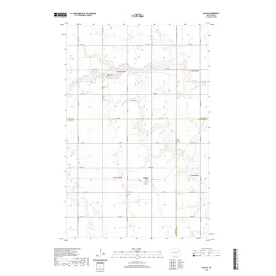
2020 Map of Dahlen
USGS Topo · Published 2020About this map
Dahlen sits at the heart of this agricultural landscape in Nelson County, where the township grid meets the meandering courses of the Forest River. The hydrology is defined by the Middle Br Forest River and the S Br Forest River, which carve distinct drainage patterns through the prairie. For those tracing local history, several burial grounds are scattered across the townships, including Quale Cem, Zion Cem, and the Middle Forest River Cem. These sites, along with Cleveland Park, provide clear markers of the early communities established in this corner of North Dakota. The map detail reflects a region organized by a strict section-line road network, such as Co RD 1 and 57th ST Ne, while the local topography reveals the subtle shifts in elevation that dictated land use and settlement throughout the late twentieth and early twenty-first centuries.
Find a feature on this map
29 named features on this map. Tap any name to fly to it.
Don’t see what you’re looking for? This feature index may not catch every label — zoom into the map to look around manually.
Map Details
Editions of this 2020 Dahlen Map
This is the sole edition of this map. No revisions or reprints were ever made.
Other maps of this area

1952 · Thief River Falls
USGS Topo · 1:250,000

1953 · Devils Lake
USGS Topo · 1:250,000

1956 · Thief River Falls
USGS Topo · 1:250,000

1956 · Devils Lake
USGS Topo · 1:250,000

1957 · Thief River Falls
USGS Topo · 1:250,000

1963 · Pleasant Valley
USGS Topo · 1:24,000

1963 · Fordville SE
USGS Topo · 1:24,000

1963 · Fordville
USGS Topo · 1:24,000

1967 · Thief River Falls
USGS Topo · 1:250,000
1971 · Michigan East
USGS Topo · 1:24,000