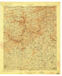
1903 Map of Dahlonega
USGS Topo · Published 1922About this map
Dahlonega and the surrounding Blue Ridge foothills are captured here during a transition from nineteenth-century mining and agriculture to early twentieth-century industrialization. The map documents the region's topography between the Nottely River and the Chattahoochee River, highlighting early transport routes like Reeds Ferry and the Southern Ry. Significant historical markers include the Indian Mounds in the Nacoochee valley and the Asbestos Mines near Sautee, indicating the varied cultural and economic layers of North Georgia.
Find a feature on this map
230 named features on this map. Tap any name to fly to it.
Don’t see what you’re looking for? This feature index may not catch every label — zoom into the map to look around manually.
Map Details
Editions of this 1903 Dahlonega Map
5 editions found

Other maps of this area

1886 · Dahlonega
USGS Topo · 1:125,000

1886 · Walhalla
USGS Topo · 1:125,000

1888 · Ellijay
USGS Topo · 1:125,000

1890 · Suwanee
USGS Topo · 1:125,000

1891 · Cowee
USGS Topo · 1:125,000

1891 · Gainesville
USGS Topo · 1:125,000

1891 · Carnesville
USGS Topo · 1:125,000

1892 · Dahlonega
USGS Topo · 1:125,000

1892 · Walhalla
USGS Topo · 1:125,000

1892 · Ellijay
USGS Topo · 1:125,000