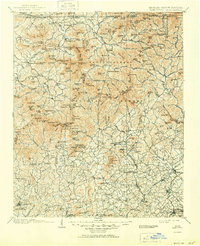
1903 Map of Dahlonega
USGS Topo · Published 1951About this map
Dahlonega and the surrounding Blue Ridge foothills appear here during a period of agricultural and industrial activity at the turn of the century. The map documents a landscape defined by the upper reaches of the Chattahoochee River and Soque River, where small settlements like Choestoe, Young Harris, and Loudsville are connected by mountain gaps and river valleys. Notable landmarks include the Indian Mounds within the Nacoochee Valley, highlighting the deep human history of the region.
Find a feature on this map
208 named features on this map. Tap any name to fly to it.
Don’t see what you’re looking for? This feature index may not catch every label — zoom into the map to look around manually.
Map Details
Editions of this 1903 Dahlonega Map
5 editions found

Other maps of this area

1886 · Dahlonega
USGS Topo · 1:125,000

1886 · Walhalla
USGS Topo · 1:125,000

1888 · Ellijay
USGS Topo · 1:125,000

1890 · Suwanee
USGS Topo · 1:125,000

1891 · Cowee
USGS Topo · 1:125,000

1891 · Gainesville
USGS Topo · 1:125,000

1891 · Carnesville
USGS Topo · 1:125,000

1892 · Dahlonega
USGS Topo · 1:125,000

1892 · Walhalla
USGS Topo · 1:125,000

1892 · Ellijay
USGS Topo · 1:125,000