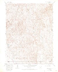
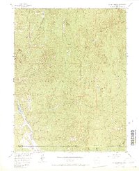
1956 Map of Dakan Mountain
USGS Topo · Published 1971About this map
The Rampart Range dominates this 1950s terrain study, revealing a high-elevation landscape within the Pike National Forest. Significant peaks including Dakan Mountain and Storm Peak anchor the topography, while the Rampart Range Road provides a primary transit corridor through the drainage systems of Jackson Creek and Bear Creek. A notable industrial footprint is visible at the Quarry situated in the northern sections, suggesting mid-century resource extraction.
Find a feature on this map
26 named features on this map. Tap any name to fly to it.
Don’t see what you’re looking for? This feature index may not catch every label — zoom into the map to look around manually.
Map Details
Editions of this 1956 Dakan Mountain Map
7 editions found
Other maps of this area

1893 · Platte Canyon
USGS Topo · 1:125,000

1894 · Castle Rock
USGS Topo · 1:125,000

1913 · Castle Rock
USGS Topo · 1:125,000

1940 · Castle Rock
USGS Topo · 1:62,500

1945 · Castle Rock
USGS Topo · 1:62,500

1953 · Denver
USGS Topo · 1:250,000

1954 · Devils Head
USGS Topo · 1:24,000

1954 · Deckers
USGS Topo · 1:24,000

1954 · Mount Deception
USGS Topo · 1:24,000
1954 · Palmer Lake
USGS Topo · 1:24,000