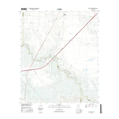
2016 Map of Dalby Springs
USGS Topo · Published 2016About this map
Dalby Springs sits at the northern edge of this Northeast Texas landscape, where the flatlands of the Red River Valley transition into a dense network of river bottoms and sloughs. The geography is dominated by the winding course of the Sulphur River and White Oak Creek, which converge to create a seasonally saturated environment of backwaters and named lakes like Flag Lake and Pine Lake. This area reflects a complex water management and land-use history, characterized by numerous private ponds and larger impoundments such as Broseco Lake Number 1 and Deer Pasture Lake.
Find a feature on this map
46 named features on this map. Tap any name to fly to it.
Don’t see what you’re looking for? This feature index may not catch every label — zoom into the map to look around manually.
Map Details
Editions of this 2016 Dalby Springs Map
This is the sole edition of this map. No revisions or reprints were ever made.
Other maps of this area

1914 · Daingerfield
USGS Topo · 1:62,500

1930 · Bassett
USGS Topo · 1:62,500

1953 · Texarkana
USGS Topo · 1:250,000

1956 · Texarkana
USGS Topo · 1:250,000

1965 · Lydia
USGS Topo · 1:24,000
1965 · Hodgson
USGS Topo · 1:24,000

1965 · Marietta
USGS Topo · 1:24,000
1965 · Malta
USGS Topo · 1:24,000

1965 · Dalby Springs
USGS Topo · 1:24,000
1965 · Bassett
USGS Topo · 1:24,000