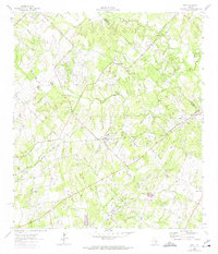
1964 Map of Dale
USGS Topo · Published 1975About this map
Industrial activity defines this Central Texas landscape, where the Lytton Springs Oil Field and Dale Oil Field dominate the terrain with numerous oil wells and a network of pipelines. The extraction economy sits alongside established rural communities like Dale and Lytton Springs, where the presence of the Missouri Kansas Texas railroad line suggests the historical importance of transit for both resources and residents. In the northeastern corner, the St John Colony area is a significant focal point for local history, featuring a dedicated St John Ch, St John Sch, and St John Cem. This 1964 survey, with revisions from 1973, reveals a landscape of family-named landmarks and essential infrastructure, from the Community Center in Dale to the scattered burial grounds like Bunton Cem and Liberty Cem, illustrating the deep-rooted settlement patterns of the region.
Find a feature on this map
31 named features on this map. Tap any name to fly to it.
Don’t see what you’re looking for? This feature index may not catch every label — zoom into the map to look around manually.
Map Details
Editions of this 1964 Dale Map
3 editions found
Other maps of this area

1885 · Bastrop
USGS Topo · 1:125,000

1893 · Bastrop
USGS Topo · 1:125,000

1896 · Austin
USGS Topo · 1:125,000

1897 · Austin
USGS Topo · 1:125,000

1901 · Flatonia
USGS Topo · 1:125,000

1904 · Bastrop
USGS Topo · 1:125,000

1910 · Austin
USGS Topo · 1:125,000

1911 · San Marcos
USGS Topo · 1:125,000

1919 · San Marcos
USGS Topo · 1:125,000

1925 · San Marcos 1-d
USGS Topo · 1:48,000