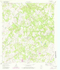
1964 Map of Dale
USGS Topo · Published 1982About this map
The Lytton Springs Oil Field and Dale Oil Field dominate this Caldwell County landscape, showing the dense network of roads and well sites that defined the local economy by the mid-1960s. The settlement of St John Colony sits in the northern portion of the map, anchored by St John Ch, while the town of Dale serves as a central hub near the Dale Cem. The industrial footprint of the petroleum industry is juxtaposed with long-established rural institutions, including the St Lytton Sch and numerous family burying grounds like the Bunton Cem and Brite Cem.
Find a feature on this map
29 named features on this map. Tap any name to fly to it.
Don’t see what you’re looking for? This feature index may not catch every label — zoom into the map to look around manually.
Map Details
Editions of this 1964 Dale Map
3 editions found
Other maps of this area

1885 · Bastrop
USGS Topo · 1:125,000

1893 · Bastrop
USGS Topo · 1:125,000

1896 · Austin
USGS Topo · 1:125,000

1897 · Austin
USGS Topo · 1:125,000

1901 · Flatonia
USGS Topo · 1:125,000

1904 · Bastrop
USGS Topo · 1:125,000

1910 · Austin
USGS Topo · 1:125,000

1911 · San Marcos
USGS Topo · 1:125,000

1919 · San Marcos
USGS Topo · 1:125,000

1925 · San Marcos 1-d
USGS Topo · 1:48,000