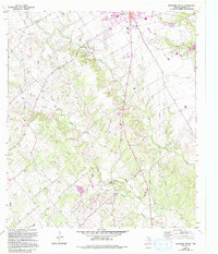
1964 Map of Lockhart South
USGS Topo · Published 1994About this map
Lockhart State Park and the rugged drainage of Clear Fork Plum Creek anchor the landscape south of the county seat. This mid-century survey illustrates a region where local agriculture and small-scale oil extraction at the Anton Oil Field coexist with outdoor recreation at the park's Rodeo Ground. The terrain is marked by a high density of family burial grounds and small communities, including Joliet and the Golden Age Home. The presence of an Old Railroad Grade and several rural schools like Clear Fork Sch suggests an earlier era of more distributed settlement along the creek valleys. Geologists and local historians will find interest in the transition from the rolling hills around Mineral Springs to the flatter plains where gravel extraction occurs at various Gravel Pit sites.
Find a feature on this map
38 named features on this map. Tap any name to fly to it.
Don’t see what you’re looking for? This feature index may not catch every label — zoom into the map to look around manually.
Map Details
Editions of this 1964 Lockhart South Map
3 editions found
Other maps of this area

1911 · San Marcos
USGS Topo · 1:125,000

1919 · San Marcos
USGS Topo · 1:125,000

1925 · San Marcos 1-d
USGS Topo · 1:48,000

1925 · San Marcos 4-a
USGS Topo · 1:48,000

1929 · Luling
USGS Topo · 1:62,500

1930 · Lockhart
USGS Topo · 1:62,500

1930 · Seguin
USGS Topo · 1:62,500

1953 · Seguin
USGS Topo · 1:250,000

1958 · Seguin
USGS Topo · 1:250,000

1963 · Lockhart North
USGS Topo · 1:24,000