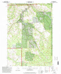
1995 Map of Dale
USGS Topo · Published 1998About this map
The North Fork John Day River cuts through the northern reaches of this landscape where Dale and the Dale Work Center serve as primary points of human settlement. Established as a protected corridor, the Ukiah-Dale Forest Wayside borders the river, providing a gateway to the expansive Umatilla National Forest. The map details a transition between high ridges like Case Ridge and deep drainages, specifically Deep Canyon and Spring Canyon. The presence of Heads Water Tank and Road Camp Spring highlights the critical infrastructure required for forest management and local travel in this mountainous area. Further south, the terrain opens into high-elevation flats such as Howard Meadows and Duff Meadows, while Meadow Brook Falls marks a significant drop in the local hydrology.
Find a feature on this map
27 named features on this map. Tap any name to fly to it.
Don’t see what you’re looking for? This feature index may not catch every label — zoom into the map to look around manually.
Map Details
Editions of this 1995 Dale Map
This is the sole edition of this map. No revisions or reprints were ever made.
Other maps of this area

1950 · Ritter
USGS Topo · 1:62,500

1951 · Dale
USGS Topo · 1:62,500

1952 · Ritter
USGS Topo · 1:62,500

1953 · Pendleton
USGS Topo · 1:250,000

1955 · Canyon City
USGS Topo · 1:250,000

1956 · Pendleton
USGS Topo · 1:250,000

1959 · Canyon City
USGS Topo · 1:250,000

1967 · Ukiah SE
USGS Topo · 1:24,000

1967 · Bridge Creek
USGS Topo · 1:24,000

1969 · Deerhorn Creek
USGS Topo · 1:24,000