
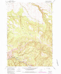
1967 Map of Ukiah SE
USGS Topo · Published 1969About this map
Umatilla National Forest defines the character of this 1960s landscape, where the North Fork John Day River and the main John Day River channel intersect. This topographical study captures the hydraulic network of the Blue Mountains, showing the complex drainage of Pine Creek, Cable Creek, and Texas Bar Creek. Named water sources like Hello Boy Spring, Basin Spring, and Overtime Spring are marked across the high country, indicating their importance for range management and forest navigation. Evidence of human activity and recreation is concentrated along the riverbanks and canyons, including the Drift Fence Campground and a Gravel Pit near the river’s edge. The map also traces the winding paths of Randall Canyon and Horse Canyon, alongside the marked river miles Mile 65 and Mile 64, which provide specific reference points for navigating the river corridor.
Find a feature on this map
32 named features on this map. Tap any name to fly to it.
Don’t see what you’re looking for? This feature index may not catch every label — zoom into the map to look around manually.
Map Details
Editions of this 1967 Ukiah SE Map
2 editions found
Other maps of this area

1951 · Dale
USGS Topo · 1:62,500

1951 · Desolation Butte
USGS Topo · 1:62,500

1953 · Pendleton
USGS Topo · 1:250,000

1955 · Canyon City
USGS Topo · 1:250,000

1956 · Pendleton
USGS Topo · 1:250,000

1959 · Canyon City
USGS Topo · 1:250,000

1967 · Lehman Springs
USGS Topo · 1:24,000

1967 · Pearson Ridge
USGS Topo · 1:24,000

1967 · Bridge Creek
USGS Topo · 1:24,000

1967 · Ukiah
USGS Topo · 1:24,000