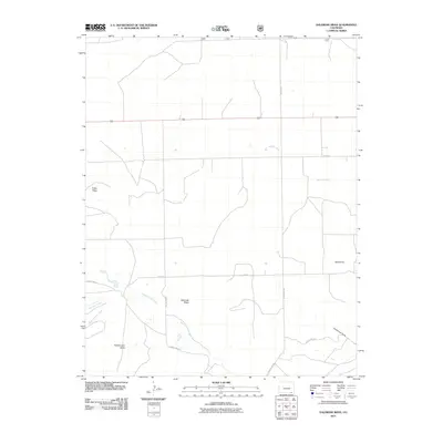
2011 Map of Dalerose Mesa
USGS Topo · Published 2011About this map
Dalerose Mesa dominates this high-altitude landscape in Las Animas County, where the high plains meet the intricate drainages of the Colorado-New Mexico borderlands. The terrain is defined by dramatic elevations and expansive plateaus, including Fallas Mesa and the prominent Frenchmans Butte. A sparse network of ranch roads, such as County Rd 191 and County Rd 24, provides the primary access across a landscape carved by seasonal watercourses. The hydrology is centered on the winding West Carrizo Creek, which is joined by tributaries like Saltillo Creek and Colorado Creek. The presence of named features like Huerfanita and Couchman Draw suggests a history of local land-use and family-held ranching territories in this arid corner of the state during the early twenty-first century.
Find a feature on this map
18 named features on this map. Tap any name to fly to it.
Don’t see what you’re looking for? This feature index may not catch every label — zoom into the map to look around manually.
Map Details
Editions of this 2011 Dalerose Mesa Map
This is the sole edition of this map. No revisions or reprints were ever made.
Other maps of this area

1891 · Mesa De Maya
USGS Topo · 1:125,000

1892 · Mt Carrizo
USGS Topo · 1:125,000

1893 · Mesa de Maya
USGS Topo · 1:125,000

1955 · La Junta
USGS Topo · 1:250,000

1958 · La Junta
USGS Topo · 1:250,000

1968 · La Junta
USGS Topo · 1:250,000
1972 · Cobert Mesa North
USGS Topo · 1:24,000

1972 · Tobe
USGS Topo · 1:24,000
1972 · Villegreen
USGS Topo · 1:24,000
1978 · Dalerose Mesa
USGS Topo · 1:24,000