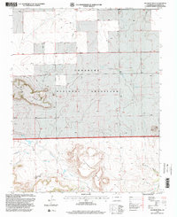
1996 Map of Dalerose Mesa
USGS Topo · Published 2000About this map
Comanche National Grassland dominates this high plains landscape in southern Colorado, where the transition from flat prairie to dramatic mesas is clearly defined by local landmarks like Fallas Mesa and Fowler Mesa. The terrain is shaped by the drainages of Saltillo Creek and West Carrizo Creek, while the massive volcanic landform of Mesa De Maya and the namesake Dalerose Mesa rise prominently above the surrounding draws.
Find a feature on this map
17 named features on this map. Tap any name to fly to it.
Don’t see what you’re looking for? This feature index may not catch every label — zoom into the map to look around manually.
Map Details
Editions of this 1996 Dalerose Mesa Map
This is the sole edition of this map. No revisions or reprints were ever made.
Other maps of this area

1891 · Mesa De Maya
USGS Topo · 1:125,000

1892 · Mt Carrizo
USGS Topo · 1:125,000

1893 · Mesa de Maya
USGS Topo · 1:125,000

1955 · La Junta
USGS Topo · 1:250,000

1958 · La Junta
USGS Topo · 1:250,000

1968 · La Junta
USGS Topo · 1:250,000
1972 · Cobert Mesa North
USGS Topo · 1:24,000

1972 · Tobe
USGS Topo · 1:24,000
1972 · Villegreen
USGS Topo · 1:24,000
1978 · Dalerose Mesa
USGS Topo · 1:24,000