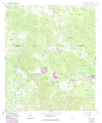
1962 Map of Daleville
USGS Topo · Published 1985About this map
Ponta Creek and its many tributaries, including Baker Creek and Mosley Branch, define the rural landscape of north Lauderdale County during the early 1960s. The settlement of Daleville sits at the heart of this area, accompanied by several smaller communities like Lizelia and Obadiah. The map documents a significant intersection of civilian life and military presence, as the northwestern edge of the Meridian Naval Air Station appears on the eastern boundary.
Find a feature on this map
34 named features on this map. Tap any name to fly to it.
Don’t see what you’re looking for? This feature index may not catch every label — zoom into the map to look around manually.
Map Details
Editions of this 1962 Daleville Map
4 editions found
Other maps of this area

1921 · Meridian
USGS Topo · 1:48,000

1923 · Meridian
USGS Topo · 1:62,500

1953 · Meridian
USGS Topo · 1:250,000

1957 · Meridian
USGS Topo · 1:250,000

1957 · Chunky
USGS Topo · 1:62,500

1962 · Daleville
USGS Topo · 1:24,000

1962 · Lauderdale
USGS Topo · 1:24,000

1962 · Lauderdale NW
USGS Topo · 1:24,000

1962 · Center Hill
USGS Topo · 1:24,000

1962 · Oak Grove
USGS Topo · 1:24,000