
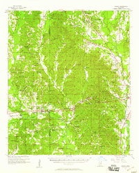
1957 Map of Chunky
USGS Topo · Published 1958About this map
The Chunky River carves through the landscape of east-central Mississippi, anchoring a network of small communities and rural congregations along the border of Newton and Lauderdale counties. During the mid-1950s, this area was defined by the intersection of major rail lines including the Illinois Central, Southern, and Gulf Mobile and Ohio railroads. These tracks connect timber and agricultural hubs like Chunky and Meehan with more isolated settlements such as Duffee and Suqualena. The map reveals a dense social infrastructure of country churches and schools, from the Pine Forest Academy to several family-named landmarks like Walker Lake and Arby Lake. Notable landmarks such as the Radio Range Station and the Tillman Lookout Tower stand out against the terrain of Tunnel Hill, while numerous small cemeteries, including Mt Carmel Cem and Hambrick Cem, provide valuable points for genealogical research across this mid-century landscape.
Find a feature on this map
87 named features on this map. Tap any name to fly to it.
Don’t see what you’re looking for? This feature index may not catch every label — zoom into the map to look around manually.
Map Details
Editions of this 1957 Chunky Map
2 editions found
Other maps of this area

1921 · Meridian
USGS Topo · 1:48,000

1923 · Meridian
USGS Topo · 1:62,500

1953 · Meridian
USGS Topo · 1:250,000

1957 · Meridian
USGS Topo · 1:250,000

1957 · Quitman
USGS Topo · 1:62,500

1957 · Enterprise
USGS Topo · 1:62,500

1962 · Daleville
USGS Topo · 1:24,000

1962 · Center Hill
USGS Topo · 1:24,000

1962 · Post
USGS Topo · 1:24,000

1965 · Meridian
USGS Topo · 1:250,000