
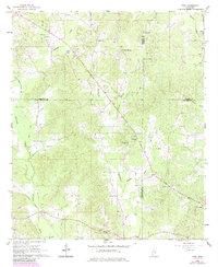
1962 Map of Post
USGS Topo · Published 1964About this map
Post and Perdue anchor this 1962 landscape in East Central Mississippi, a region defined by the convergence of four counties: Neshoba, Kemper, Newton, and Lauderdale. The Gulf Mobile and Ohio railroad corridor provides a clear industrial artery through the south, passing near the small settlement at Perdue. This era reveals a deeply religious and community-focused rural geography, marked by a high density of country churches and family burial grounds including Pleasant Hill Ch, Alawine Springs Ch, and the Trussel Cem.
Find a feature on this map
41 named features on this map. Tap any name to fly to it.
Don’t see what you’re looking for? This feature index may not catch every label — zoom into the map to look around manually.
Map Details
Editions of this 1962 Post Map
2 editions found
Other maps of this area

1953 · Meridian
USGS Topo · 1:250,000

1957 · Meridian
USGS Topo · 1:250,000

1957 · Chunky
USGS Topo · 1:62,500

1962 · House
USGS Topo · 1:24,000

1962 · Center Hill
USGS Topo · 1:24,000

1962 · Moscow
USGS Topo · 1:24,000

1965 · Meridian
USGS Topo · 1:250,000

1966 · Decatur
USGS Topo · 1:24,000

1972 · Deemer
USGS Topo · 1:24,000

1972 · Union East
USGS Topo · 1:24,000