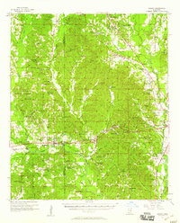
1957 Map of Chunky
USGS Topo · Published 1958About this map
The Chunky River winds through the heart of the Newton and Lauderdale County border, defining a landscape where the Illinois Central and Southern railroads intersect. This 1950s survey documents a densely settled rural network of family churches and community schools, such as the Pine Forest Academy and the Du Bose Sch with its adjacent Du Bose Sch Cem. The topography is characterized by the prominent Lost Gap Hill and the passage through Lost Gap, while the eastern edge of the map shows the transition toward the municipal infrastructure of Key Field, complete with a Gaging Station and Radio Range Station. The distribution of cemeteries like McGee Cem and Hambrick Cem provides a detailed genealogical record for researchers tracing the families that populated Chunky, Meehan, and Suqualena during the mid-century era.
Find a feature on this map
93 named features on this map. Tap any name to fly to it.
Don’t see what you’re looking for? This feature index may not catch every label — zoom into the map to look around manually.
Map Details
Editions of this 1957 Chunky Map
2 editions found
Other maps of this area

1921 · Meridian
USGS Topo · 1:48,000

1923 · Meridian
USGS Topo · 1:62,500

1953 · Meridian
USGS Topo · 1:250,000

1957 · Meridian
USGS Topo · 1:250,000

1957 · Chunky
USGS Topo · 1:62,500

1957 · Quitman
USGS Topo · 1:62,500

1957 · Enterprise
USGS Topo · 1:62,500

1962 · Daleville
USGS Topo · 1:24,000

1962 · Center Hill
USGS Topo · 1:24,000

1962 · Post
USGS Topo · 1:24,000