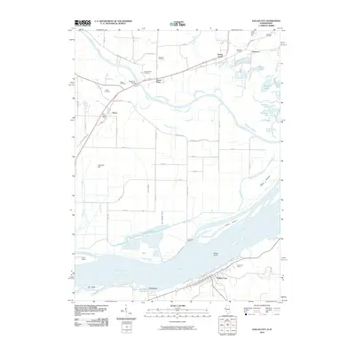
2010 Map of Dallas City
USGS Topo · Published 2010About this map
The Mississippi River forms the central character of this riverfront landscape, dividing the communities of Dallas City and Pontoosuc on the eastern bank from the lowland sloughs and islands to the west. The river’s shifting topography is evident in the numerous water bodies and backwaters such as Half Moon Lake, Lost Slough, and Patterson Lake. On the higher ground north of the Skunk River, a dense concentration of historical burial sites including Beebe Cemetery, Mohnike Cemetery, and South Walker Cemetery suggests deep roots for the families of the surrounding farmsteads.
Find a feature on this map
54 named features on this map. Tap any name to fly to it.
Don’t see what you’re looking for? This feature index may not catch every label — zoom into the map to look around manually.
Map Details
Editions of this 2010 Dallas City Map
This is the sole edition of this map. No revisions or reprints were ever made.
Other maps of this area

1932 · Lomax
USGS Topo · 1:62,500

1934 · Burlington
USGS Topo · 1:48,000

1936 · Fort Madison
USGS Topo · 1:62,500

1937 · Lomax
USGS Topo · 1:62,500

1940 · Burlington
USGS Topo · 1:62,500

1958 · Burlington
USGS Topo · 1:250,000

1961 · Burlington
USGS Topo · 1:250,000

1963 · Burlington
USGS Topo · 1:250,000
1964 · Burlington
USGS Topo · 1:24,000

1964 · Lomax
USGS Topo · 1:24,000