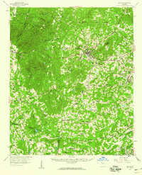
1958 Map of Dallas
USGS Topo · Published 1960About this map
Dallas serves as the focal point of this Paulding County survey, where the junction of the Southern and Seaboard railroads defined the local economy during the late 1950s. The landscape is heavily marked by rural communities and their spiritual centers, such as Mt Tabor Ch, New Canaan Ch, and Friendship Ch. To the northwest, the terrain rises toward Elsberry Mtn, while the southern reaches are drained by the meandering Sweetwater Creek. Notable landmarks include a Drive-in Theater near Dallas and a private Airstrip (Private) to the south, reflecting mid-century development patterns. Genealogists will find value in the numerous cemeteries and scattered settlements like McPherson, Hanlin, and New Hope, many of which remain connected by established routes like the Hiram Sudie Road and Braswell Road.
Find a feature on this map
72 named features on this map. Tap any name to fly to it.
Don’t see what you’re looking for? This feature index may not catch every label — zoom into the map to look around manually.
Map Details
Editions of this 1958 Dallas Map
2 editions found
Other maps of this area

1886 · Rome
USGS Topo · 1:125,000

1889 · Tallapoosa
USGS Topo · 1:125,000

1890 · Cartersville
USGS Topo · 1:125,000

1891 · Marietta
USGS Topo · 1:125,000

1891 · Cartersville
USGS Topo · 1:125,000

1892 · Tallapoosa
USGS Topo · 1:125,000

1895 · Marietta
USGS Topo · 1:125,000

1896 · Cartersville
USGS Topo · 1:125,000

1897 · Marietta
USGS Topo · 1:125,000

1897 · Tallapoosa
USGS Topo · 1:125,000