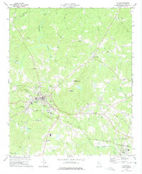
1973 Map of Dallas
USGS Topo · Published 1975About this map
Dallas serves as the focal point of this Paulding County landscape, situated at a junction where the Southern Railway and the Seaboard Coast Line converge. The surrounding terrain is defined by the drainages of Pumpkinvine Creek and Picketts Mill Creek, with Elsberry Mountain providing a prominent elevation marked by a Lookout Tower. The map reveals a community structured around rural education and faith, with numerous small institutions like Matthews Sch and Shady Grove Ch distributed along a winding network of local roads.
Find a feature on this map
48 named features on this map. Tap any name to fly to it.
Don’t see what you’re looking for? This feature index may not catch every label — zoom into the map to look around manually.
Map Details
Editions of this 1973 Dallas Map
Other maps of this area

1890 · Cartersville
USGS Topo · 1:125,000

1891 · Marietta
USGS Topo · 1:125,000

1891 · Cartersville
USGS Topo · 1:125,000

1895 · Marietta
USGS Topo · 1:125,000

1896 · Cartersville
USGS Topo · 1:125,000

1897 · Marietta
USGS Topo · 1:125,000

1901 · Marietta
USGS Topo · 1:125,000

1906 · Stilesboro
USGS Topo · 1:62,500

1907 · Acworth
USGS Topo · 1:62,500

1908 · Stilesboro
USGS Topo · 1:62,500