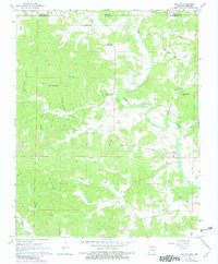
1968 Map of Dalton
USGS Topo · Published 1982About this map
The Eleven Point River carves a winding path through the Ozark foothills, defining the rural character of this borderland between Arkansas and Missouri. The settlement of Dalton serves as a small focal point near the river, while the surrounding landscape is marked by a network of family-named hollows and ridges, such as Dubois Hollow and Nubbin Ridge. This 1968 survey, photorevised in the early 1980s, captures a snapshot of a deeply rooted community where local history is anchored by its numerous burial grounds, including Dalton Cem and King Cem.
Find a feature on this map
44 named features on this map. Tap any name to fly to it.
Don’t see what you’re looking for? This feature index may not catch every label — zoom into the map to look around manually.
Map Details
Editions of this 1968 Dalton Map
2 editions found
Other maps of this area

1941 · Gatewood
USGS Topo · 1:62,500

1944 · Couch
USGS Topo · 1:62,500

1945 · Gatewood
USGS Topo · 1:62,500

1946 · Couch
USGS Topo · 1:62,500

1957 · Poplar Bluff
USGS Topo · 1:250,000

1959 · Poplar Bluff
USGS Topo · 1:250,000

1960 · Poplar Bluff
USGS Topo · 1:250,000

1965 · Gatewood
USGS Topo · 1:24,000

1966 · Ravenden Springs
USGS Topo · 1:24,000
1966 · Ravenden Springs SE
USGS Topo · 1:24,000