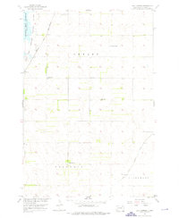
1954 Map of Daly Corners
USGS Topo · Published 1976About this map
Sand Lake and the National Wildlife Refuge dominate the northwestern corner of this mid-century survey of Brown County. The landscape is defined by the industrial and agricultural infrastructure of the eastern Dakotas, featuring the Chicago and North Western railroad line cutting through the north and a network of water management features like the Crow Creek Drainage Ditch. The transition between Shelby, Columbia, and Claremont townships is meticulously documented, showing the dispersed nature of settlement in this prairie region.
Find a feature on this map
14 named features on this map. Tap any name to fly to it.
Don’t see what you’re looking for? This feature index may not catch every label — zoom into the map to look around manually.
Map Details
Editions of this 1954 Daly Corners Map
3 editions found

Other maps of this area

1894 · Hecla
USGS Topo · 1:62,500

1894 · Columbia
USGS Topo · 1:62,500

1894 · Savo
USGS Topo · 1:62,500

1896 · Columbia
USGS Topo · 1:125,000

1952 · Huffton
USGS Topo · 1:24,000

1952 · Columbia
USGS Topo · 1:24,000

1952 · Columbia NE
USGS Topo · 1:24,000

1952 · Putney
USGS Topo · 1:24,000

1953 · Hecla SE
USGS Topo · 1:24,000

1953 · Houghton
USGS Topo · 1:24,000