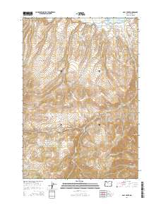
2014 Map of Daly Creek
USGS Topo · Published 2014About this map
The Powder River flows through the northern reaches of this Baker County landscape, eventually meeting the Brownlee Reservoir along the eastern edge of the survey. This 2014 edition highlights the complex drainage systems of the region, where waterways like Daly Creek, Chalk Cr, and the N Fork Daly Cr carve through high-elevation terrain. Human management of the water is evident through the presence of the Stegle Ditch and access routes like Snake River Rd and Swan Ranch Rd.
Find a feature on this map
32 named features on this map. Tap any name to fly to it.
Don’t see what you’re looking for? This feature index may not catch every label — zoom into the map to look around manually.
Map Details
Editions of this 2014 Daly Creek Map
This is the sole edition of this map. No revisions or reprints were ever made.
Other maps of this area

1915 · Pine
USGS Topo · 1:125,000

1955 · Baker
USGS Topo · 1:250,000

1957 · Halfway
USGS Topo · 1:62,500

1957 · Sparta
USGS Topo · 1:62,500

1957 · Durkee
USGS Topo · 1:62,500

1957 · Mineral
USGS Topo · 1:62,500

1959 · Baker
USGS Topo · 1:250,000

1981 · Baker
USGS Topo · 1:100,000
1987 · Richland
USGS Topo · 1:24,000
1987 · Connor Creek
USGS Topo · 1:24,000