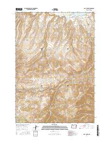
2017 Map of Daly Creek
USGS Topo · Published 2017About this map
Powder River and the Brownlee Reservoir dominate the northern landscape of this Baker County quadrangle. The topography is defined by the complex drainage systems of Daly Creek and its tributaries, including N Fork Daly Cr and Cherry Spring Cr, which carve through steep gulches like Rock Gulch and Myers Gulch. This 2017 survey reflects a largely undeveloped terrain where access is limited to a few arterial routes such as Snake River Rd and Daly Creek Rd. High plateaus like Peavine Flat and Lower Peavine Flat stand above the surrounding valleys. The map documents the persistent ranching and water management infrastructure of the region, evidenced by landmarks such as the Sass and Shaw Ranch Rd and various water sources like Poison Spring and Cherry Spring.
Find a feature on this map
32 named features on this map. Tap any name to fly to it.
Don’t see what you’re looking for? This feature index may not catch every label — zoom into the map to look around manually.
Map Details
Editions of this 2017 Daly Creek Map
This is the sole edition of this map. No revisions or reprints were ever made.
Other maps of this area

1915 · Pine
USGS Topo · 1:125,000

1955 · Baker
USGS Topo · 1:250,000

1957 · Halfway
USGS Topo · 1:62,500

1957 · Sparta
USGS Topo · 1:62,500

1957 · Durkee
USGS Topo · 1:62,500

1957 · Mineral
USGS Topo · 1:62,500

1959 · Baker
USGS Topo · 1:250,000

1981 · Baker
USGS Topo · 1:100,000
1987 · Richland
USGS Topo · 1:24,000
1987 · Connor Creek
USGS Topo · 1:24,000