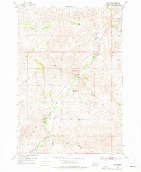
1952 Map of Dalys
USGS Topo · Published 1976About this map
The Beaverhead River valley serves as the primary corridor for transportation and settlement in this portion of Montana, where the Union Pacific railroad parallels the water's edge. This 1952 field-checked environment is defined by established family operations, including the Mooney Ranch and Henneberry Ranch, which are situated along the valley floor and foothills. Small railroad stops or clusters like Dalys and Grayling mark the infrastructure of the early 1950s.
Find a feature on this map
25 named features on this map. Tap any name to fly to it.
Don’t see what you’re looking for? This feature index may not catch every label — zoom into the map to look around manually.
Map Details
Editions of this 1952 Dalys Map
4 editions found
Other maps of this area

1893 · Dillon
USGS Topo · 1:250,000

1952 · Bannack
USGS Topo · 1:24,000

1952 · Burns Mountain
USGS Topo · 1:24,000

1952 · Eli Spring
USGS Topo · 1:24,000

1952 · Dalys
USGS Topo · 1:24,000

1952 · Gallagher Mountain
USGS Topo · 1:24,000

1955 · Dubois
USGS Topo · 1:250,000

1955 · Dillon
USGS Topo · 1:250,000

1957 · Dillon
USGS Topo · 1:250,000

1958 · Dubois
USGS Topo · 1:250,000