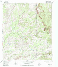
1959 Map of Dam Draw
USGS Topo · Published 1985About this map
The industrial and natural landscape of West Texas is sharply defined along the boundary of Mitchell Co and Nolan Co. The southern portion of the sheet is dominated by energy and transportation infrastructure, specifically the McCabe Oil Field, which is marked by numerous oil wells, gas wells, and an extensive network of pipelines. This industrial activity is anchored by the Panhandle and Santa Fe railroad line, which cuts through the southeastern corner.
Find a feature on this map
16 named features on this map. Tap any name to fly to it.
Don’t see what you’re looking for? This feature index may not catch every label — zoom into the map to look around manually.
Map Details
Editions of this 1959 Dam Draw Map
3 editions found
Other maps of this area

1950 · Colorado City SE
USGS Topo · 1:24,000

1954 · Big Spring
USGS Topo · 1:250,000

1958 · Big Spring
USGS Topo · 1:250,000

1959 · Pecan Crossing
USGS Topo · 1:24,000

1959 · Dam Draw
USGS Topo · 1:24,000

1959 · Silver
USGS Topo · 1:24,000

1959 · Dead Indian Mountain
USGS Topo · 1:24,000

1962 · Sanco
USGS Topo · 1:24,000

1969 · Baumann School
USGS Topo · 1:24,000

1969 · Bench Mountain
USGS Topo · 1:24,000