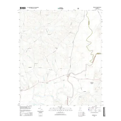
2014 Map of Damascus
USGS Topo · Published 2014About this map
The Conecuh River and Sepulga River define the southern and eastern landscape of this corner of Escambia and Conecuh counties. Near the river confluence, the McGowin Ferry Bridge serves as a key crossing point, reflecting the importance of water access for this timber-rich region. The area is heavily influenced by the Conecuh National Forest, which blankets much of the terrain south of Us-29.
Find a feature on this map
54 named features on this map. Tap any name to fly to it.
Don’t see what you’re looking for? This feature index may not catch every label — zoom into the map to look around manually.
Map Details
Editions of this 2014 Damascus Map
This is the sole edition of this map. No revisions or reprints were ever made.
Other maps of this area

1953 · Andalusia
USGS Topo · 1:250,000

1957 · Andalusia
USGS Topo · 1:250,000

1971 · Dixie
USGS Topo · 1:24,000

1971 · Bradley
USGS Topo · 1:24,000

1971 · Loango
USGS Topo · 1:24,000

1982 · Shipps Creek
USGS Topo · 1:24,000
1982 · Roberts
USGS Topo · 1:24,000

1982 · Damascus
USGS Topo · 1:24,000

1982 · Nymph
USGS Topo · 1:24,000
1982 · Brooklyn
USGS Topo · 1:24,000