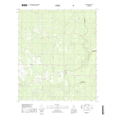
2018 Map of Damascus
USGS Topo · Published 2018About this map
The confluence of the Sepulga River and the Conecuh River defines this landscape in southern Alabama, where river-bottom lowlands meet the rising pine woods of the Conecuh National Forest. The settlement of Damascus serves as a local hub, surrounded by family-named landmarks such as Hoomesville Church Cem and Damascus Cem. Further south, the community of Boykin sits near the riverbanks, illustrating the historical importance of these waterways for transport and trade. The map documents numerous creek systems, including Meeting-House Cr and Grab Mill Cr, which suggest early local industry and congregation points. Transportation heritage is evident at McGowin Bridge, located near the McGowin Ferry Cem, marking a point where travelers once crossed the winding Conecuh River.
Find a feature on this map
55 named features on this map. Tap any name to fly to it.
Don’t see what you’re looking for? This feature index may not catch every label — zoom into the map to look around manually.
Map Details
Editions of this 2018 Damascus Map
This is the sole edition of this map. No revisions or reprints were ever made.
Other maps of this area

1953 · Andalusia
USGS Topo · 1:250,000

1957 · Andalusia
USGS Topo · 1:250,000

1971 · Dixie
USGS Topo · 1:24,000

1971 · Bradley
USGS Topo · 1:24,000

1971 · Loango
USGS Topo · 1:24,000

1982 · Shipps Creek
USGS Topo · 1:24,000
1982 · Roberts
USGS Topo · 1:24,000

1982 · Damascus
USGS Topo · 1:24,000

1982 · Nymph
USGS Topo · 1:24,000
1982 · Brooklyn
USGS Topo · 1:24,000