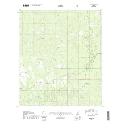
2021 Map of Damascus
USGS Topo · Published 2021About this map
The Sepulga River and Conecuh River converge in this corner of south Alabama, shaping a landscape defined by its waterways and timberlands. Small rural settlements like Damascus and Boykin serve as the primary hubs for a network of county roads including Damascus Rd and Brooklyn Rd. The survey records several significant burial sites that offer value for genealogical research, such as Hoomesville Church Cem, McGowin Ferry Cem, and Foshee Cem. Much of the eastern and southern portions of the territory fall within the Conecuh National Forest, where drainage features like Hell Hole Cr and Folley Cr feed into the river system. Notable infrastructure includes the McGowan Bridge, providing a crossing point near the convergence of the two rivers.
Find a feature on this map
54 named features on this map. Tap any name to fly to it.
Don’t see what you’re looking for? This feature index may not catch every label — zoom into the map to look around manually.
Map Details
Editions of this 2021 Damascus Map
This is the sole edition of this map. No revisions or reprints were ever made.
Other maps of this area

1953 · Andalusia
USGS Topo · 1:250,000

1957 · Andalusia
USGS Topo · 1:250,000

1971 · Dixie
USGS Topo · 1:24,000

1971 · Bradley
USGS Topo · 1:24,000

1971 · Loango
USGS Topo · 1:24,000

1982 · Shipps Creek
USGS Topo · 1:24,000
1982 · Roberts
USGS Topo · 1:24,000

1982 · Damascus
USGS Topo · 1:24,000

1982 · Nymph
USGS Topo · 1:24,000
1982 · Brooklyn
USGS Topo · 1:24,000