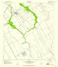
1943 Map of Danbury
USGS Topo · Published 1959About this map
The settlement of Danbury serves as the focal point of this coastal prairie landscape during the early 1940s. Situated along the Missouri Pacific railroad, the town's grid is clearly defined against a backdrop of extensive agricultural drainage and irrigation infrastructure. The winding course of Austin Bayou and Flores Bayou dominate the drainage pattern, with the former supported by a Pumping Sta and a dedicated Reservoir. This era of the Brazoria County coast is characterized by the transition from traditional ranching and farming toward industrial utility, evidenced by the presence of an Oil Well and the linear path of Hoskins Mound Road. Small watercourses like Eagle Gully and Brushy Bayou intersect the flat terrain, illustrating the complex hydrologic management required for rice farming and local industry in the Texas Gulf Coast region.
Find a feature on this map
13 named features on this map. Tap any name to fly to it.
Don’t see what you’re looking for? This feature index may not catch every label — zoom into the map to look around manually.
Map Details
Editions of this 1943 Danbury Map
2 editions found
Other maps of this area

1932 · Mustang Bayou
USGS Topo · 1:31,680

1943 · Oyster Creek
USGS Topo · 1:31,680

1943 · Rosharon
USGS Topo · 1:31,680

1943 · Danbury
USGS Topo · 1:31,680

1943 · Mustang Bayou
USGS Topo · 1:31,680

1943 · Angleton
USGS Topo · 1:24,000

1943 · Christmas Point
USGS Topo · 1:24,000

1943 · Chocolate Bay
USGS Topo · 1:24,000

1943 · Chocolate Bayou
USGS Topo · 1:24,000

1943 · Snipe
USGS Topo · 1:31,680