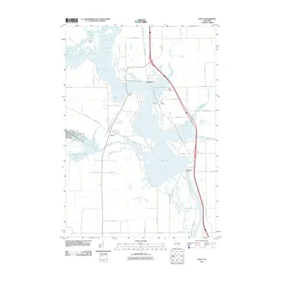
2010 Map of Dancy
USGS Topo · Published 2010About this map
The Wisconsin River and the sprawling waters of Lake Du Bay dominate this landscape south of Knowlton, where the river's flow is regulated by the Dubay 2 WP 533 Dam. This 2010 topographic record captures the geography of Marathon County as the Little Eau Pleine River enters from the west, creating the complex wetlands of the Little Eau Pleine Flowage. The settlement of Dancy sits near the confluence of these waters, reflecting a community shaped by the river system.
Find a feature on this map
51 named features on this map. Tap any name to fly to it.
Don’t see what you’re looking for? This feature index may not catch every label — zoom into the map to look around manually.
Map Details
Editions of this 2010 Dancy Map
This is the sole edition of this map. No revisions or reprints were ever made.
Other maps of this area
1899 · Wausau
USGS Topo · 1:125,000
1902 · Wausau
USGS Topo · 1:125,000

1902 · Marathon
USGS Topo · 1:125,000

1953 · Wausau
USGS Topo · 1:48,000
1953 · Marathon
USGS Topo · 1:48,000

1955 · Green Bay
USGS Topo · 1:250,000
1956 · Milladore
USGS Topo · 1:48,000
1956 · Stevens Point
USGS Topo · 1:48,000
1963 · Marathon
USGS Topo · 1:62,500

1963 · Wausau
USGS Topo · 1:62,500