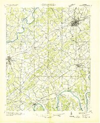
1935 Map of Dandridge
USGS Topo · Published 1935About this map
The French Broad River and Holston River dominate the East Tennessee landscape of the mid-1930s, framing a region of fertile river bottoms and ridges before the massive hydrological changes of the Tennessee Valley Authority took hold. This field examination, conducted for the Tennessee Valley Authority by the U.S. Geological Survey, meticulously details the agrarian and industrial infrastructure of the day, from the concentrated grid of Morristown to the rural crossings at Dandridge.
Find a feature on this map
108 named features on this map. Tap any name to fly to it.
Don’t see what you’re looking for? This feature index may not catch every label — zoom into the map to look around manually.
Map Details
Editions of this 1935 Dandridge Map
This is the sole edition of this map. No revisions or reprints were ever made.
Other maps of this area

1883 · Morristown
USGS Topo · 1:125,000

1886 · Knoxville
USGS Topo · 1:125,000

1892 · Knoxville
USGS Topo · 1:125,000

1893 · Mt Guyot
USGS Topo · 1:125,000

1893 · Morristown
USGS Topo · 1:125,000

1894 · Knoxville
USGS Topo · 1:125,000

1895 · Morristown
USGS Topo · 1:125,000

1895 · Knoxville
USGS Topo · 1:125,000

1897 · Maynardville
USGS Topo · 1:125,000

1900 · Maynardville
USGS Topo · 1:125,000