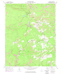
1969 Map of Danese
USGS Topo · Published 1977About this map
Danese and the coal-mining communities of the New River Gorge plateau are captured here in the late 1960s, showing a landscape defined by industrial extraction and small-town infrastructure. The presence of numerous Strip Mine operations, Tipple sites, and Conveyors reflects the dominant economy, particularly around Landisburg and Layland. These mines are deeply integrated into the terrain, often located just yards from family landmarks like Smailes Cem and Zickafoose Ch Cem. The transition from valley floors to the high ridges of Mann Mountain and Walnut Ridge is documented through a network of service roads and the Ohio And Chesapeake rail line.
Find a feature on this map
64 named features on this map. Tap any name to fly to it.
Don’t see what you’re looking for? This feature index may not catch every label — zoom into the map to look around manually.
Map Details
Editions of this 1969 Danese Map
3 editions found
Other maps of this area

1887 · Hinton
USGS Topo · 1:125,000

1889 · Nicholas
USGS Topo · 1:125,000

1891 · Nicholas
USGS Topo · 1:125,000

1891 · Raleigh
USGS Topo · 1:125,000

1892 · Hinton
USGS Topo · 1:125,000

1897 · Kanawha Falls
USGS Topo · 1:125,000

1897 · Raleigh
USGS Topo · 1:125,000

1900 · Kanawha Falls
USGS Topo · 1:125,000

1901 · Nicholas
USGS Topo · 1:125,000

1901 · Kanawha Falls
USGS Topo · 1:125,000