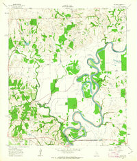
1961 Map of Daniels
USGS Topo · Published 1963About this map
The Brazos River creates a serpentine border along the eastern edge of this landscape, its path defined by dramatic meanders like Mexican Bend and the wide alluvial reach of Clark Bottom. In the early 1960s, this area of Washington and Waller counties remained a largely rural patchwork of agricultural land and scattered communities. Small settlements such as Goodwill and Daniels are shown alongside local landmarks like Brown College and several rural congregations, including Paul Felder Ch and Mt Calvary Ch. The drainage patterns are clearly visible, with Jackson Creek and New Year Creek cutting through the western terrain to feed the river. The presence of several small cemeteries, such as Franklin Cem, and a primitive Landing Strip near the river bank, provide specific points of interest for genealogists and local historians documenting the mid-century development of these riverfront communities.
Find a feature on this map
30 named features on this map. Tap any name to fly to it.
Don’t see what you’re looking for? This feature index may not catch every label — zoom into the map to look around manually.
Map Details
Editions of this 1961 Daniels Map
2 editions found
Other maps of this area

1914 · Gay Hill
USGS Topo · 1:62,500

1914 · Navasota
USGS Topo · 1:62,500

1930 · Brenham
USGS Topo · 1:62,500

1954 · Austin
USGS Topo · 1:250,000

1956 · Hempstead
USGS Topo · 1:62,500

1956 · Brenham
USGS Topo · 1:62,500

1958 · Washington
USGS Topo · 1:24,000

1958 · Courtney
USGS Topo · 1:24,000

1959 · Independence
USGS Topo · 1:24,000
1961 · Hempstead
USGS Topo · 1:24,000