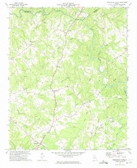
1972 Map of Danielsville North
USGS Topo · Published 1974About this map
The county seat of Danielsville anchors the southern edge of this Madison County landscape as it appeared in the early 1970s. The region is defined by a dense network of watercourses including the Hudson River and the Broad River, where numerous small creeks like Masons Mill Creek and Shiloh Creek carve through the terrain. The map reveals a deeply rooted rural community, illustrated by the frequent pairing of local churches and their adjacent cemeteries, such as New Hope Ch and New Hope Cem near the settlement of Bond.
Find a feature on this map
41 named features on this map. Tap any name to fly to it.
Don’t see what you’re looking for? This feature index may not catch every label — zoom into the map to look around manually.
Map Details
Editions of this 1972 Danielsville North Map
2 editions found
Other maps of this area

1891 · Carnesville
USGS Topo · 1:125,000

1954 · Greenville
USGS Topo · 1:250,000

1958 · Greenville
USGS Topo · 1:250,000

1958 · Danielsville
USGS Topo · 1:62,500

1959 · Carnesville
USGS Topo · 1:24,000

1959 · Royston
USGS Topo · 1:24,000

1964 · Ila
USGS Topo · 1:24,000

1964 · Ashland
USGS Topo · 1:24,000

1964 · Hull
USGS Topo · 1:24,000
1972 · Danielsville South
USGS Topo · 1:24,000