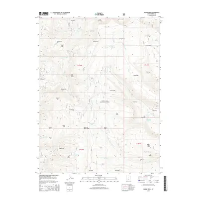
2014 Map of Danish Knoll
USGS Topo · Published 2014About this map
Danish Knoll sits at the heart of this high-elevation landscape within the Manti-Lasal National Forest, where the terrain is defined by a complex network of canyons and ridges. The map reveals an intricate early 21st-century water management system characterized by the Wasatch Ditch, Larsen Ditch, and Madsen Ditch, which redirect snowmelt across the Wasatch Plateau. Several engineering feats are noted, including the Horseshoe Tunnel, Larson Tunnel, and Ephraim Tunnel, illustrating the vital importance of water rights and conveyance in Sanpete County.
Find a feature on this map
74 named features on this map. Tap any name to fly to it.
Don’t see what you’re looking for? This feature index may not catch every label — zoom into the map to look around manually.
Map Details
Editions of this 2014 Danish Knoll Map
This is the sole edition of this map. No revisions or reprints were ever made.
Other maps of this area

1885 · Manti
USGS Topo · 1:250,000

1895 · Manti
USGS Topo · 1:250,000

1922 · Wasatch
USGS Topo · 1:31,680

1956 · Price
USGS Topo · 1:250,000

1960 · Price
USGS Topo · 1:250,000

1962 · Price
USGS Topo · 1:250,000

1965 · Black Mountain
USGS Topo · 1:24,000
1966 · Ferron Reservoir
USGS Topo · 1:24,000

1966 · Spring City
USGS Topo · 1:24,000

1966 · Chester
USGS Topo · 1:24,000